
Black Canyon of the Gunnison South Rim. This comprehensive guide covers everything you need to know about exploring the scenic drive, 12 spectacular overlooks, hiking trails, and essential visitor information for this underrated Colorado gem.
Overview of Black Canyon of the Gunnison South Rim
The Black Canyon of the Gunnison South Rim represents the more accessible and developed side of this remarkable national park. During my visits over the past decade, I've witnessed firsthand how this dramatic landscape captivates visitors with its steep, dark walls that plunge nearly 2,000 feet to the rushing Gunnison River below.
What makes the South Rim special is its year-round accessibility and comprehensive facilities. Unlike the more primitive North Rim, the South Rim offers paved roads, a full-service visitor center, developed campgrounds, and 12 distinct overlooks that showcase different perspectives of this geological marvel. The park rangers I've spoken with consistently recommend the South Rim for first-time visitors due to its superior infrastructure and easier navigation.
The canyon's nickname "Black Canyon" comes from the dark Precambrian rocks that form its walls, some of the oldest exposed rock in North America at nearly 2 billion years old. The narrow opening at the top allows limited sunlight to reach the bottom, creating an almost perpetual twilight that adds to the canyon's mysterious atmosphere.
Essential Gear for Your South Rim Adventure
Based on my extensive hiking experience in Colorado's national parks, proper footwear is crucial for navigating the rocky trails to various overlooks. I highly recommend investing in quality hiking boots that provide ankle support and traction on uneven surfaces.
🥾 Get Timberland Hiking Boots 📖 National Parks Adventure GuideFor planning your visit, I strongly recommend checking out our detailed guide on how many days you need for Black Canyon of the Gunnison to optimize your itinerary. Most visitors spend 1-2 days exploring the South Rim, which provides ample time to drive the scenic route and experience the major overlooks.
The 7-Mile South Rim Scenic Drive Experience
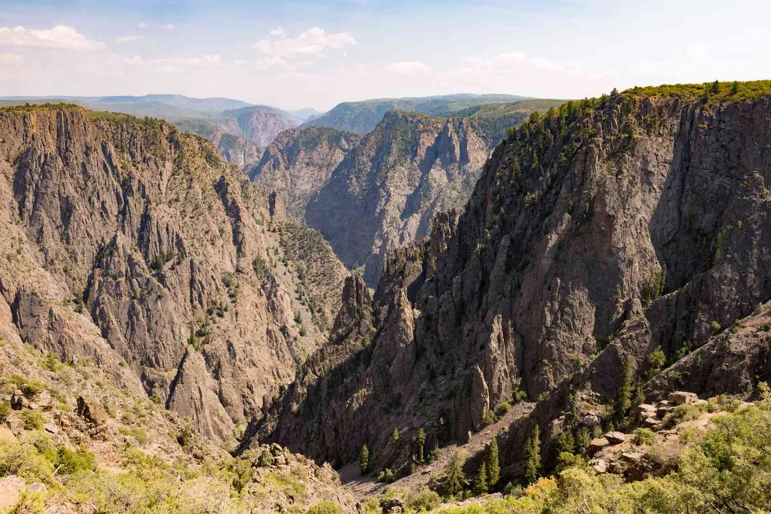
The Black Canyon of the Gunnison South Rim scenic drive is arguably one of the most spectacular short drives in the National Park System. This 7-mile paved road stretches from Tomichi Point near the visitor center to High Point at the road's terminus, offering access to 12 unique overlooks along the way.
South Rim Drive scenic tour showcasing the breathtaking overlooks
During my numerous trips along this route, I've learned that the drive itself takes about 30 minutes without stops, but I always recommend allowing 3-4 hours to properly experience the overlooks. Each viewpoint offers a different perspective of the canyon, and some require short walks of up to 600 yards from the parking areas.
Key Features of the Scenic Drive
The road begins at an elevation of approximately 8,100 feet and provides stunning views throughout its length. What I find most remarkable is how each overlook reveals different geological features and canyon perspectives. The western overlooks showcase the canyon's dramatic width, while the eastern viewpoints highlight the incredible depth and the famous Painted Wall.
Parking can be challenging during peak summer months, particularly at popular spots like Gunnison Point and Painted Wall. I've found that visiting early morning (before 9 AM) or late afternoon provides the best combination of available parking and optimal lighting for photography. The accommodation options near Black Canyon can help you plan an early start.
Pro Tip for Photographers
The golden hour lighting (first and last hour of sunlight) creates incredible contrast against the dark canyon walls. I've captured my best shots during these times, particularly at Sunset View and Dragon Point.
🏔️ Get Black Canyon Commemorative PatchThe road remains open year-round to the visitor center, but the section beyond the visitor center closes during winter months due to snow. Rangers conduct regular safety inspections and provide current road conditions at the entrance station. For those wondering about which side of Black Canyon is best, the South Rim's year-round accessibility gives it a significant advantage over the North Rim.
Must-See Overlooks on the Black Canyon South Rim
After visiting all 12 overlooks multiple times, I've identified the absolute must-see viewpoints that showcase the Black Canyon of the Gunnison South Rim at its most spectacular. Each offers unique geological features and photographic opportunities that define this remarkable landscape.
Gunnison Point: The Gateway View
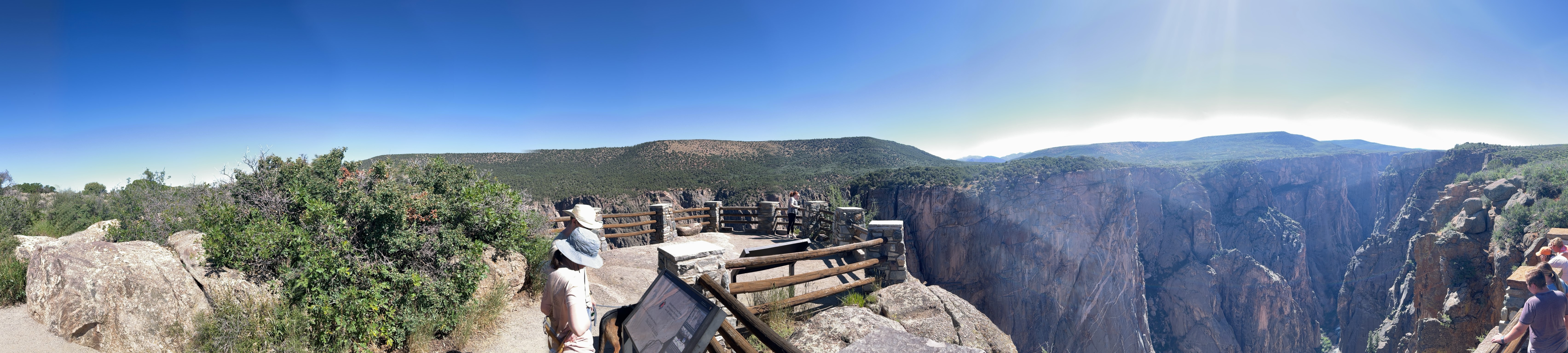
Located just steps from the visitor center, Gunnison Point provides the perfect introduction to the canyon's immensity. This easily accessible overlook requires only a 100-yard walk downhill from the parking area. The panoramic view here encompasses the full width of the canyon, making it an excellent spot for orientation and understanding the scale of this geological wonder.
What makes Gunnison Point special is its educational value. The National Park Service has installed interpretive panels that explain the canyon's formation, and I often see park rangers conducting impromptu geology talks here. The view extends both east and west along the canyon, providing context for the other overlooks you'll visit during your drive.
Chasm View: The Narrowest Point
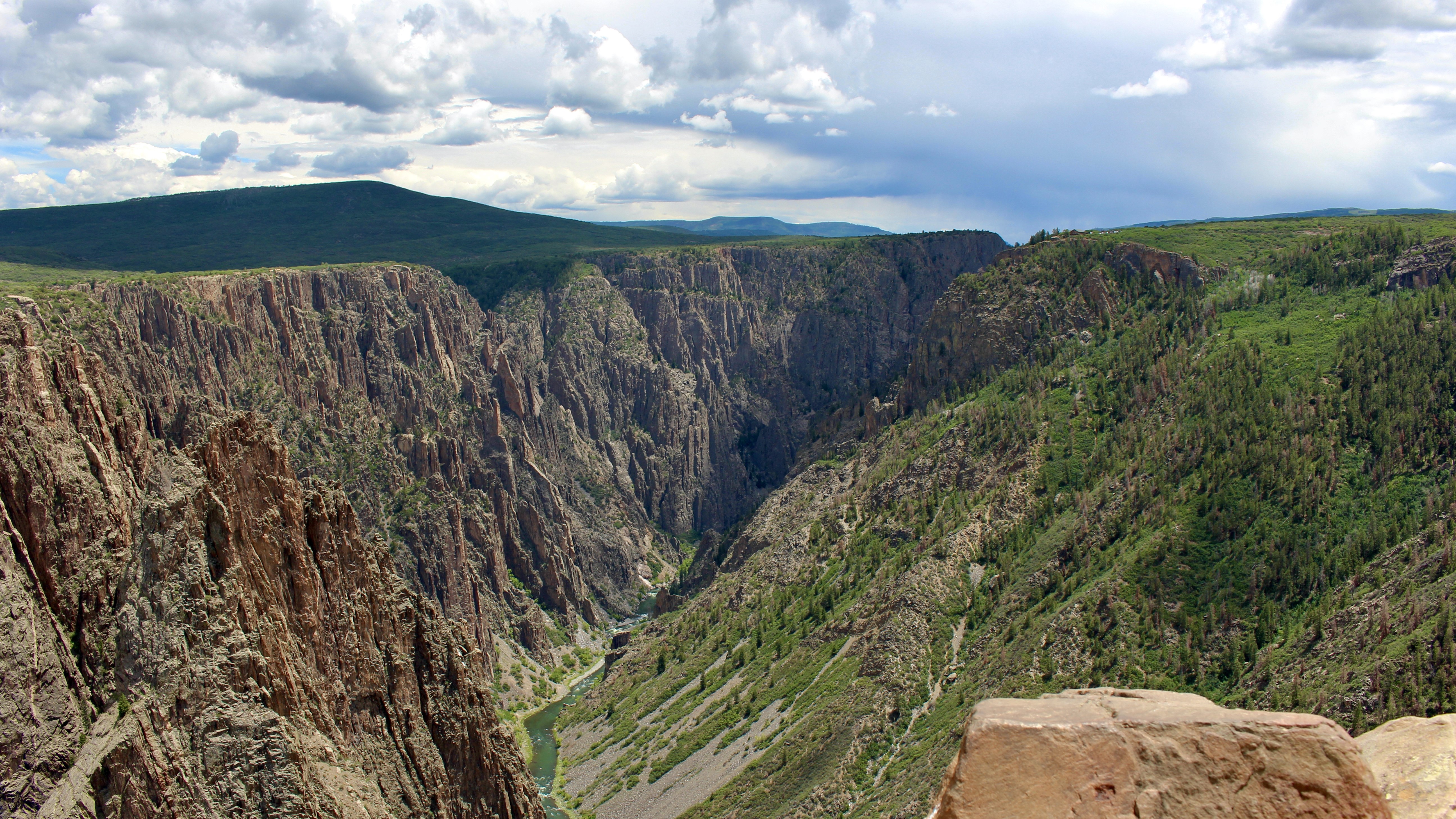
Chasm View showcases the canyon at its narrowest point, where the walls are only 1,100 feet apart at the rim. Standing here, I'm always amazed by how the massive walls seem to close in, creating an almost claustrophobic feeling despite being on top of the rim. The vertical drop here is particularly dramatic, with walls that are nearly vertical for their entire 1,800-foot descent.
The walk to Chasm View is short—about 100 yards from the parking area—but the impact is immediate. This viewpoint perfectly illustrates why early explorers found the canyon so challenging to cross. The Gunnison River appears as a thin ribbon far below, and on quiet days, you can sometimes hear the water rushing through the rocky narrows.
Painted Wall: Colorado's Tallest Cliff
The Painted Wall represents the crown jewel of Black Canyon of the Gunnison South Rim overlooks. At 2,250 feet high, this is Colorado's tallest cliff face, and the light-colored pegmatite intrusions create striking patterns against the dark rock. These formations, created over a billion years ago when molten rock squeezed into cracks in the existing stone, create natural artwork on a massive scale.
The 200-yard walk to the Painted Wall overlook is one of the longer approaches, but absolutely worth the effort. I recommend bringing binoculars to fully appreciate the intricate details of the pegmatite formations. The contrast between the white intrusions and the dark schist creates patterns that change throughout the day as lighting conditions shift.
Essential Viewing Equipment
To fully appreciate the geological details and wildlife spotting opportunities, quality binoculars are indispensable. I've also found that a good hiking guidebook enhances the educational aspect of the visit.
📚 Colorado Trail Guide 🗺️ National Geographic Trail MapDragon Point and Cedar Point: River Views
These two overlooks provide the best views of the Gunnison River and showcase the canyon from an upstream perspective. Dragon Point requires only a 100-yard walk and offers similar views to the more distant Cedar Point Nature Trail, making it an efficient choice for those with limited time or mobility.
From these vantages, the engineering marvel of the Gunnison River becomes apparent. Over two million years, this relatively small river carved through some of the hardest rock in North America, creating the deepest and most dramatic section of the entire canyon system. The view downstream shows how the canyon continues beyond the park boundaries.
For those planning their visit, our guide on the nearest town to Black Canyon of the Gunnison provides valuable information about lodging and services in nearby Montrose, which serves as the primary gateway for South Rim visitors.
Hiking Adventures Beyond the Overlooks
While the Black Canyon of the Gunnison South Rim scenic drive provides spectacular views, the hiking trails offer more intimate experiences with this dramatic landscape. During my years of exploring these trails, I've discovered that each provides unique perspectives and varying levels of challenge suitable for different fitness levels and time constraints.
Oak Flat Loop Trail: Into the Canyon
The Oak Flat Loop Trail stands out as the most adventurous hiking option on the South Rim, offering the rare opportunity to descend partway into the canyon itself. This 2-mile loop trail drops approximately 350 feet below the rim, providing a dramatically different perspective of the towering canyon walls from below.
Starting from the visitor center, the trail initially follows a forested path before beginning its descent into the canyon via switchbacks. What I find most remarkable about this hike is how the perspective shifts as you descend. The canyon walls that appeared massive from above become truly overwhelming as you stand beneath them. The trail provides several clearings where the full scale of the surrounding cliffs becomes apparent.
The hike is rated as strenuous, primarily due to the elevation gain on the return climb rather than technical difficulty. I recommend allowing 2-3 hours for the complete loop, depending on your pace and time spent at the viewpoints. The trail is well-maintained but can be slippery when wet, making proper footwear essential.
Rim Rock Trail: Easy Canyon Edge Walk
For those seeking a gentler hiking experience, the Rim Rock Trail provides a perfect introduction to canyon edge walking. This 1-mile trail connects the visitor center to the South Rim Campground, following the canyon rim with minimal elevation change. The path passes through Tomichi Point, the first official overlook on the scenic drive.
What makes this trail special is its accessibility and interpretive opportunities. The relatively flat path allows hikers to focus on the geology and ecology rather than challenging terrain. Several informal viewpoints along the route provide quiet spots for contemplation away from the busier designated overlooks.
Warner Point Nature Trail: Valley Views
Located at the end of the scenic drive near High Point, the Warner Point Nature Trail offers a completely different perspective from the main canyon views. This 1.5-mile round-trip hike leads to a viewpoint overlooking the Uncompahgre Valley and the distant San Juan Mountains, providing context for the canyon's place in Colorado's broader landscape.
The trail showcases the ecosystem that exists above the canyon rim, featuring high-desert vegetation adapted to the elevation and climate. Interpretive signs along the route explain the plant communities and wildlife that thrive in this environment. From Warner Point, you can see how the Black Canyon gradually opens into the wider valley below.
Safety Considerations for Canyon Hiking
Canyon edge hiking requires constant awareness of your surroundings. Weather can change rapidly at this elevation, and afternoon thunderstorms are common during summer months. I always carry extra layers and rain protection, even on clear mornings.
Essential safety items:
- Plenty of water (at least 1 liter per person)
- Weather protection layers
- Sturdy hiking boots with good traction
- First aid supplies
- Emergency whistle
Inner Canyon Routes: Advanced Adventures
For experienced hikers seeking the ultimate Black Canyon of the Gunnison South Rim adventure, three unmarked routes descend to the canyon floor: the Gunnison Route, Tomichi Route, and East Portal Route. These are not maintained trails but rather designated wilderness routes requiring permits and advanced hiking skills.
I've completed the Gunnison Route several times, and it remains one of the most challenging hikes in the Colorado National Parks system. The route drops 1,800 feet in just 1.5 miles, requiring scrambling over loose rock and using fixed chains in some sections. The reward is reaching the Gunnison River and experiencing the canyon from its bottom, surrounded by walls that seem to stretch infinitely upward.
These routes require wilderness permits available at the visitor center and should only be attempted by experienced hikers with proper equipment and canyon navigation skills. The park service recommends planning triple the descent time for the return climb, making these full-day commitments even for strong hikers.
Essential Visitor Information and Planning Tips
Planning a successful visit to the Black Canyon of the Gunnison South Rim requires understanding the park's facilities, seasonal considerations, and logistical details. Through my extensive experience visiting during different seasons and conditions, I've compiled the essential information to help maximize your canyon experience.
South Rim Visitor Center and Facilities
The South Rim Visitor Center serves as the primary hub for park information and services. Open year-round with seasonal hour variations, the center features comprehensive exhibits about the canyon's geology, ecology, and human history. The park film provides an excellent introduction to the canyon's formation and significance within the Colorado Plateau region.
Park rangers staff the visitor center and provide invaluable expertise about current conditions, weather forecasts, and activity recommendations. I always stop here first to check on any trail closures, road conditions, or special programs scheduled during my visit. The center also houses a well-stocked bookstore with field guides, maps, and educational materials specific to the Black Canyon region.
Water availability varies seasonally, with fill-up stations operating only during summer months at the visitor center and campground. All water is trucked in, so conservation is important, and I recommend bringing adequate supplies rather than relying entirely on park sources. Restroom facilities are available at the visitor center and several overlook locations.
Seasonal Considerations and Weather
The Black Canyon of the Gunnison South Rim experiences significant seasonal variations that dramatically affect the visitor experience. Summer months (June through September) provide the most accessible conditions with all roads and facilities open, but also bring the largest crowds and afternoon thunderstorms that can develop rapidly.
Spring and fall offer excellent visiting conditions with moderate temperatures and fewer crowds, though weather can be unpredictable. I particularly enjoy autumn visits when aspen trees in the surrounding areas provide golden contrast to the dark canyon walls. Winter visits are possible but limited, as the scenic drive beyond the visitor center typically closes due to snow conditions.
Elevation at the rim averages 8,100 feet, meaning temperatures are typically 10-15 degrees cooler than in nearby Montrose. I always pack layers regardless of season, as conditions can change rapidly. Summer highs reach the 80s Fahrenheit, while winter temperatures can drop well below freezing with significant snowfall.
Current Park Information
Stay updated on current conditions, road closures, and special programs by checking the official National Park Service website or calling the visitor center. Construction projects occasionally impact parking and access to certain overlooks.
Park Fees (2025):
- Private Vehicle: $30 (7 days)
- Individual: $15 (7 days)
- Annual Black Canyon Pass: $55
- America the Beautiful Annual Pass: $80
Camping and Accommodation Options
The South Rim Campground provides the closest accommodation to the canyon overlooks, featuring 88 sites in three loops. Two loops accept reservations through Recreation.gov, while Loop A operates on a first-come, first-served basis. During my camping experiences here, I've found the sites well-spaced and private, though facilities are basic with vault toilets and no showers.
Campsites fill regularly during peak season (July and August), particularly on weekends. I recommend making reservations well in advance or arriving early in the day for first-come sites. The campground provides easy access to the Rim Rock Trail and serves as an excellent base for exploring both the scenic drive and hiking trails.
For those preferring hotel accommodations, the town of Montrose lies approximately 15 miles from the park entrance and offers various lodging options. For detailed information about staying near the park, consult our comprehensive guide on where to stay in Black Canyon of the Gunnison.
East Portal Road: Alternative Canyon Access
One unique feature of the Black Canyon of the Gunnison South Rim is the East Portal Road, which provides vehicular access to the canyon bottom. This steep, winding road drops 1,800 feet in just 5 miles, offering a completely different perspective of the canyon walls from below.
The road requires careful driving with recommended low gear usage to prevent brake overheating on the steep grades that reach 16% in some sections. RVs and trailers over certain sizes are prohibited due to the challenging conditions. At the bottom, the East Portal area provides picnicking opportunities, fishing access to the Gunnison River, and a small first-come, first-served campground.
Standing at the bottom and looking up at the towering walls provides perspective impossible to gain from the rim overlooks. The East Portal Road typically opens in spring and closes with the first significant snowfall, similar to the upper section of the South Rim Drive.
Whether you're planning a day trip or an extended stay, understanding these logistical details ensures a smooth and enjoyable visit to this remarkable Colorado destination. For more information about planning your visit duration, check our guide on Black Canyon of the Gunnison South Rim planning recommendations.
Conclusion
The Black Canyon of the Gunnison South Rim stands as one of Colorado's most underappreciated natural treasures, offering dramatic vistas and geological wonders that rival any national park in the system. Through its accessible 7-mile scenic drive, 12 spectacular overlooks, and diverse hiking opportunities, the South Rim provides experiences suitable for every visitor, from families seeking scenic drives to adventurous hikers pursuing inner canyon routes.
What sets this destination apart is its combination of accessibility and raw natural beauty. Unlike many popular national parks where crowds can diminish the experience, the Black Canyon maintains an intimate atmosphere that allows for genuine connection with the landscape. The park's relatively compact size means you can experience its highlights in a single day, yet the depth and complexity of the canyon ensure that return visits always reveal new details and perspectives.
My years of exploring this remarkable landscape have reinforced my belief that the Black Canyon of the Gunnison South Rim deserves a place on every serious nature lover's itinerary. Whether you're drawn by the geological significance of 2-billion-year-old rocks, the engineering marvel of the Gunnison River's erosive power, or simply the breathtaking beauty of one of America's most dramatic canyons, this destination will exceed your expectations and create lasting memories of Colorado's natural heritage.
Ready to Explore Black Canyon of the Gunnison?
Equip yourself with the essential gear and information needed for an unforgettable South Rim adventure.
Plan your visit today and discover why the Black Canyon of the Gunnison South Rim represents one of the American West's most spectacular and accessible natural wonders. The dramatic cliffs, ancient geology, and stunning vistas await your exploration in this remarkable Colorado destination.