
.webp)
Planning your journey to Colorado's most underrated national park? This comprehensive guide covers everything you need to know about how to get to Black Canyon of the Gunnison, including detailed driving directions to both rims, transportation options, distances from major cities, and insider tips from my personal visits to help you plan the perfect trip to this spectacular canyon carved by the Gunnison River. Whether you're coming from Denver, Grand Junction, or other Colorado destinations, I'll show you the best routes and what to expect along the way. Visit Wilderness Paths for more national park travel guides.
Park Overview and Location
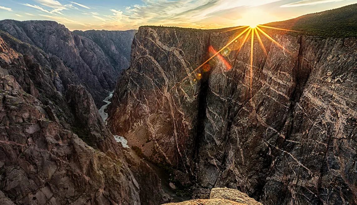
Black Canyon of the Gunnison National Park stands as one of Colorado's most dramatic and least visited national treasures. Located in southwestern Colorado, this remarkable park preserves 12 miles of the most spectacular section of the 48-mile-long Black Canyon carved by the Gunnison River. When visitors ask me how to get to Black Canyon of the Gunnison, I always emphasize that this journey rewards you with some of the most breathtaking canyon views in the American West.
During my multiple visits to the park, I've discovered that understanding the geography is crucial for planning your trip. The park is divided into two distinct areas: the popular and accessible South Rim, and the more remote and rugged North Rim. Unlike the Grand Canyon, there's no bridge connecting these two sides, so choosing your destination affects your entire travel strategy.
The canyon earned its name from the dark Precambrian rock that lines its walls, some nearly 2 billion years old. In the narrowest sections, the canyon is so deep and narrow that some areas receive only 33 minutes of sunlight per day. This geological marvel attracts photographers, hikers, and adventurers seeking an alternative to Colorado's more crowded national parks.
The park officially became a national park in 1999, though it had been protected as a national monument since 1933. With only about 360,000 visitors annually, it remains one of the least crowded national parks in the United States. This makes it an ideal destination for those seeking solitude and pristine wilderness experiences. For more information about camping options, check out our detailed guide on Black Canyon of the Gunnison Wilderness camping opportunities.
Understanding how to get to Black Canyon of the Gunnison begins with recognizing that most visitors focus on the South Rim due to its year-round accessibility and proximity to Montrose, the nearest major town. However, adventurous travelers shouldn't overlook the North Rim, which offers some of the most spectacular viewpoints in the entire park, including the famous Exclamation Point overlook.
Getting to the South Rim
South Rim Address and Basic Directions
Physical/GPS Address: 9800 Highway 347, Montrose, CO 81401
The South Rim serves as the primary entrance to Black Canyon of the Gunnison National Park and remains open year-round. From my experience visiting during different seasons, this accessibility makes it the preferred choice for most travelers wondering how to get to Black Canyon of the Gunnison.
From Montrose (20 minutes)
Montrose serves as the gateway city for South Rim access. From downtown Montrose, head east on US Highway 50 for approximately 6 miles. You'll see clear signs directing you to turn left (north) onto Colorado Highway 347. Follow this scenic route for about 7 miles straight to the park entrance station.
I've found this route particularly enjoyable during early morning hours when the light creates stunning contrasts on the surrounding mesas. The drive offers glimpses of the Uncompahgre Valley and provides a perfect warm-up for the dramatic canyon views ahead.
From Grand Junction (75 minutes)
From Grand Junction, take US Highway 50 south for approximately 60 miles to Montrose. This scenic drive through the Colorado Plateau offers beautiful high desert landscapes. Once in Montrose, follow the directions above to reach the park entrance.
The Grand Junction to Montrose route passes through several charming Colorado communities including Delta, where you can stop for supplies or fuel. I recommend allowing extra time for this drive to enjoy the changing landscapes and perhaps spot some of the area's abundant wildlife.
What to Expect at the South Rim
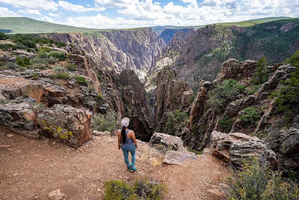
Upon arrival at the South Rim, you'll find the visitor center, which serves as an excellent starting point for understanding the park's geology and history. The South Rim Drive extends for 7 miles from Tomichi Point to High Point, featuring 12 spectacular overlooks. Each viewpoint offers unique perspectives of the canyon's depths and the Gunnison River far below.
For visitors planning extended stays, I highly recommend exploring our guide on where to stay in Black Canyon of the Gunnison for accommodation options in the Montrose area. The South Rim also provides access to the dramatic East Portal Road, which descends 2,000 feet to the Gunnison River with grades reaching 16%.
Important Note: The East Portal Road requires vehicles with good brakes and is not recommended for RVs over 22 feet or trailers. Rangers frequently check this road during busy periods.
Getting to the North Rim
North Rim Address and Basic Information
Physical/GPS Address: 7295 Black Canyon Road, Crawford, CO
The North Rim offers a more remote and adventurous experience for those learning how to get to Black Canyon of the Gunnison. This less-visited side of the park closes to vehicles during winter months (typically November through April) but rewards visitors with some of the most spectacular canyon views in North America.
Detailed Driving Directions to North Rim
Reaching the North Rim requires more planning than the South Rim journey. From Montrose, the drive takes approximately 90 minutes and covers about 63 miles. The route takes you through rural Colorado farmland and offers a completely different perspective on accessing the canyon.
Step-by-Step North Rim Directions from Montrose:
- From Montrose, head north on US Highway 50 for about 21 miles to the town of Delta
- In Delta, turn right (east) onto Colorado Highway 92
- Follow Highway 92 east for approximately 35 miles through scenic ranching country
- About 3 miles south of Crawford, turn west onto Black Canyon Road (well-marked)
- Follow Black Canyon Road for 11 miles to reach the North Rim entrance
- Note: The final 7 miles are unpaved but well-maintained gravel road suitable for all vehicles
During my visits to the North Rim, I've encountered significantly fewer visitors compared to the South Rim, creating an almost private wilderness experience. The unpaved road might concern some travelers, but it's well-maintained and accessible to standard passenger vehicles. I've successfully navigated it in both sedans and SUVs without any issues.
North Rim Highlights and Considerations
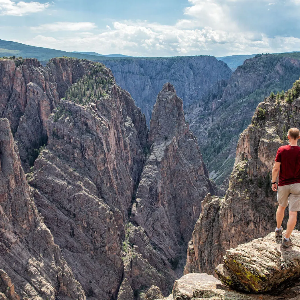
The North Rim Drive spans only 4.5 miles compared to the South Rim's 7-mile road, but it delivers some of the park's most dramatic viewpoints. Exclamation Point, accessible via a moderate 3-mile round-trip hike, provides what many consider the single best view in the entire park. The perspective looking straight down the canyon axis is simply unmatched.
For hikers interested in more challenging adventures, the North Rim serves as the starting point for several inner canyon routes. These routes require wilderness permits and excellent physical fitness, but they offer access to some of the most remote and pristine areas of the park. Be sure to consult our guide on how many days to spend at Black Canyon when planning extended North Rim adventures.
Pro Tip: Allow 2-3 hours to drive between the North and South Rims. There's no bridge across the canyon, so you must loop around through the towns of Delta and Crawford.
Transportation Options
When planning how to get to Black Canyon of the Gunnison, understanding your transportation options is crucial for a successful visit. The park's remote location in southwestern Colorado means that personal vehicle access is the most practical and popular choice, though several alternatives exist for different travel preferences and budgets.
Personal Vehicle (Recommended)
Driving your own vehicle provides the most flexibility and convenience when visiting Black Canyon of the Gunnison. The park has no public transportation within its boundaries, and having your own vehicle allows you to explore at your own pace, visit multiple overlooks, and carry necessary gear for hiking or photography.
All park roads are paved except for the final 7 miles to the North Rim, which is well-maintained gravel suitable for standard passenger vehicles. During winter months, snow tires or chains may be required for safe travel.
Fly and Rent
The closest major airport is Grand Junction Regional Airport (GJT), located about 75 miles from the park. Denver International Airport (DEN) is 300 miles away but offers more flight options and potentially better rates.
Car rental agencies operate at both airports, with Grand Junction providing the shorter drive time. I recommend booking rental cars in advance, especially during peak season (May through October), as availability can be limited in this rural area.
Bus Service
Greyhound and other bus services provide connections to Montrose, Gunnison, and Grand Junction. However, no public transportation extends into the park itself, so you'll need to arrange additional transportation from these cities.
Some visitors combine bus travel with ride-sharing services or taxi companies in Montrose, though options are limited. This approach works best for day visits to the South Rim only.
Tour Services
Several regional tour companies offer guided trips to Black Canyon of the Gunnison, often combined with other Colorado attractions. These services typically originate from Grand Junction, Durango, or Aspen and include transportation, guides, and sometimes meals.
While more expensive than independent travel, guided tours can provide valuable insights and handle all logistics, making them ideal for visitors with limited time or those preferring structured experiences.
Essential Gear for Your Journey
Regardless of your chosen transportation method, proper preparation enhances your Black Canyon experience. Based on my multiple visits, I recommend these essential items for anyone learning how to get to Black Canyon of the Gunnison:
Quality Hiking Boots
The rocky terrain and potentially steep trails require proper footwear for safety and comfort.
Shop Hiking BootsDay Pack
Essential for carrying water, snacks, and gear during rim walks and viewpoint visits.
Shop Day PacksBinoculars
Perfect for wildlife viewing and getting detailed looks at the canyon's geological features.
Shop BinocularsNational Parks Pass
Save money if visiting multiple parks, plus support conservation efforts across the park system.
Get Your PassDistances from Major Cities
Understanding driving distances and times is essential when planning how to get to Black Canyon of the Gunnison. The park's location in southwestern Colorado makes it accessible from multiple directions, each offering unique scenic routes and travel experiences. I've compiled this comprehensive distance guide based on my extensive travels throughout Colorado and the surrounding region.
Distance Chart to South Rim (via Montrose)
Colorado Cities
- Denver300 miles (5 hours)
- Colorado Springs235 miles (4.75 hours)
- Grand Junction60 miles (1 hour)
- Gunnison63 miles (1.25 hours)
- Aspen135 miles (3 hours)
Regional Destinations
- Ouray36 miles (45 minutes)
- Telluride65 miles (1.5 hours)
- Durango110 miles (2.5 hours)
- Crested Butte85 miles (2 hours)
- Steamboat Springs180 miles (3.5 hours)
National Park Connections
Black Canyon of the Gunnison's location makes it an excellent addition to Colorado national park road trips. Many visitors combine it with other parks, and understanding these distances helps in planning efficient multi-park itineraries:
- Mesa Verde National Park: 140 miles (3 hours) - A perfect combination of geological and archaeological wonders
- Great Sand Dunes National Park: 195 miles (3.5 hours) - Contrasting landscapes within reasonable driving distance
- Rocky Mountain National Park: 312 miles (5 hours) - Feasible for extended Colorado tours
- Colorado National Monument: 90 miles (1.5 hours) - Similar geological features with different perspectives
Scenic Route Recommendations
When considering how to get to Black Canyon of the Gunnison, the journey can be as memorable as the destination. I've traveled all major routes to the park and can recommend several particularly scenic approaches that enhance the overall experience:
From Denver via US-285 South: This route takes you through the San Luis Valley, offering views of the Sangre de Cristo Mountains and passing through historic towns like Alamosa. The drive is longer than the direct interstate route but provides stunning mountain scenery and a more authentic Colorado experience.
Million Dollar Highway (US-550): If approaching from the Durango area, the Million Dollar Highway through Silverton and Ouray ranks among America's most spectacular mountain drives. The route includes dramatic cliff-side driving and breathtaking alpine vistas, though it requires careful attention, especially in winter conditions.
For those planning to visit during spring, our Black Canyon of the Gunnison in April guide provides essential information about seasonal conditions and road accessibility.
.webp)
Practical Travel Tips
After numerous visits to Black Canyon of the Gunnison, I've learned that successful trips require more than just knowing how to get to Black Canyon of the Gunnison. The park's remote location, dramatic elevation changes, and variable weather conditions demand careful preparation and insider knowledge that only comes from experience.
Fuel and Services
No gas stations exist within the park boundaries, making fuel planning crucial. The nearest stations are in Montrose for South Rim visitors and Crawford for North Rim access. I always recommend starting with a full tank, especially when visiting both rims in one day.
Cell phone coverage is limited throughout the park, so download maps and important information before entering. The visitor center provides the most reliable communication point for emergencies.
Weather Considerations
Weather can change rapidly at the canyon's 8,000+ foot elevation. I've experienced snow in June and warm temperatures in November. Layer clothing and bring rain gear regardless of the forecast. Summer temperatures can reach 90°F, while winter lows drop well below freezing.
Wind is constant along the rim, especially at exposed viewpoints. Secure hats and loose items, and consider wind-resistant clothing for extended outdoor activities.
Safety Reminders
The canyon's dramatic drops demand respect and caution. Stay behind designated barriers and never venture onto unstable rock ledges for photos. I've witnessed too many close calls from visitors attempting dangerous selfies.
Wildlife includes black bears, mountain lions, and rattlesnakes. Store food properly, make noise while hiking, and never approach or feed any animals. Carry bear spray if planning backcountry activities.
Timing Your Visit
South Rim Road typically opens by early April and closes with the first significant snowfall, usually in mid-November. North Rim closes earlier, often by late October. Check current conditions before traveling, especially during shoulder seasons.
Early morning and late afternoon provide the best lighting for photography and wildlife viewing. Midday visits can be harsh due to bright sun and strong shadows in the canyon.
Elevation and Health Considerations
Black Canyon of the Gunnison sits at elevations between 5,479 feet at the river level to over 9,000 feet at some rim areas. Visitors coming from sea level may experience altitude effects including shortness of breath, fatigue, or headaches. I recommend taking frequent breaks, staying hydrated, and avoiding strenuous activities on your first day at elevation.
The dry Colorado air can be dehydrating, especially combined with high elevation and physical activity. Carry more water than you think you'll need - I recommend at least one gallon per person for day visits, more for hiking or extended outdoor activities.
Best Times to Visit
Peak season runs from Memorial Day through Labor Day, offering the most reliable weather but also the highest visitor numbers. My favorite times are late September through early October when autumn colors enhance the canyon's natural beauty and temperatures remain comfortable for hiking.
Spring visits (April through May) can be spectacular but unpredictable, with possible late-season snowstorms alternating with warm, sunny days. Winter visits to the South Rim offer unique beauty and solitude, though facilities are limited and weather conditions can be challenging.
For detailed planning information, including seasonal considerations and activity recommendations, check out our comprehensive complete guide to visiting Black Canyon of the Gunnison.
Essential Items Checklist:
- Sunscreen (SPF 30+)
- Hat and sunglasses
- Layered clothing
- Camera with extra batteries
- Plenty of water
- Snacks and lunch
- First aid kit
- Park map and guidebook
Conclusion
Understanding how to get to Black Canyon of the Gunnison opens the door to one of America's most spectacular yet underappreciated national parks. Through my extensive exploration of both rims and various approach routes, I've learned that the journey to this remarkable canyon is as rewarding as the destination itself. The park's remote location in southwestern Colorado, while requiring more planning than some national parks, ensures that visitors experience the kind of pristine wilderness and dramatic landscapes that are becoming increasingly rare in our crowded world.
Whether you choose the accessible South Rim with its paved roads and comprehensive facilities, or venture to the more remote North Rim for solitude and spectacular viewpoints like Exclamation Point, Black Canyon of the Gunnison rewards every visitor with unforgettable experiences. The key lies in proper preparation, understanding the different access routes, and respecting the unique challenges that come with visiting this high-elevation wilderness area.
Key Takeaways for Your Visit
- The South Rim (9800 Highway 347, Montrose, CO) offers year-round access and comprehensive facilities
- The North Rim (7295 Black Canyon Road, Crawford, CO) provides more solitude but requires seasonal planning
- Personal vehicle transportation is essential; no public transit serves the park
- Grand Junction (60 miles) and Montrose (14 miles) serve as the primary gateway cities
- Allow 2-3 hours to travel between rims due to the lack of canyon bridges
- Fuel up before entering the park - no gas stations exist within park boundaries
- Weather can change rapidly; prepare for various conditions regardless of season
The effort required to reach Black Canyon of the Gunnison makes the experience all the more meaningful. This park represents what national parks were meant to preserve: wild, untamed landscapes where visitors can connect with nature on its own terms. The dramatic canyon walls, carved over millions of years by the relentless Gunnison River, stand as testament to the power of natural forces and the importance of protecting these irreplaceable treasures.
As you plan your journey, remember that how to get to Black Canyon of the Gunnison is just the beginning of your adventure. The park offers everything from easy rim walks suitable for families to challenging inner canyon routes that test experienced hikers. The key is matching your expectations and preparation to the type of experience you seek.
I encourage you to approach your visit with patience and reverence for this incredible landscape. Take time to truly absorb the canyon's immense scale and geological significance. Listen to the silence that pervades the rim areas, broken only by the distant sound of the Gunnison River far below. These moments of connection with the natural world make the journey worthwhile and create memories that last a lifetime.
Black Canyon of the Gunnison awaits your discovery. With proper planning, respect for the environment, and an adventurous spirit, your visit to this remarkable national park will undoubtedly rank among your most memorable outdoor experiences. Safe travels, and enjoy every moment of your journey to one of America's most spectacular natural wonders.