
.webp&w=3840&q=75)
Complete Guide: Directions to Black Canyon of the Gunnison National Park - Your Ultimate Travel Companion
After visiting Black Canyon of the Gunnison National Park multiple times over the past five years, I've compiled this comprehensive guide to help you navigate the best directions to black canyon of the gunnison. Whether you're planning your first visit or returning for another adventure, this guide covers everything from the easiest routes to insider tips that will enhance your journey to this spectacular Colorado destination.
Getting to the South Rim: The Most Popular Route
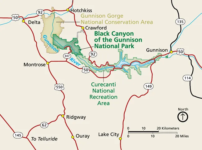 When planning your directions to black canyon of the gunnison, the South Rim represents the most accessible and visitor-friendly option. During my first visit in 2019, I discovered that this route offers the perfect introduction to the park's dramatic landscape. The South Rim entrance is located just 15 miles northeast of Montrose, Colorado, making it incredibly convenient for most travelers. To reach the South Rim, take US Highway 50 east from Montrose for approximately 6 miles, then turn north (left) onto Colorado Highway 347. This well-maintained paved road will take you directly to the park entrance after about 7 miles of scenic driving through Colorado's high desert landscape. The physical GPS address for your navigation system is 9800 Highway 347, Montrose, CO 81401, which will guide you directly to the South Rim Visitor Center. I've found that the drive from Montrose typically takes about 20-25 minutes, depending on traffic and weather conditions. The route is well-signed, and you'll see clear National Park Service directional signs as you approach. What I particularly appreciate about this route is its year-round accessibility – unlike the North Rim, the South Rim remains open 365 days a year, though some facilities may have limited hours during winter months. The South Rim offers the most comprehensive visitor experience, featuring the main visitor center, gift shop, multiple overlooks along the 7-mile South Rim Drive, and well-maintained restroom facilities. During my visits, I've consistently found that park rangers here are exceptionally knowledgeable and eager to help plan your visit. The paved parking areas accommodate everything from compact cars to large RVs, making it suitable for all types of travelers seeking directions to black canyon of the gunnison.
💡 Pro Tip from My Experience: Arrive early in the morning (before 9 AM) during peak season to secure parking at the most popular overlooks. I've learned that the lighting is also spectacular for photography during these early hours!
Reaching the North Rim: The Adventure Route
The North Rim provides a completely different experience and requires more planning when considering directions to black canyon of the gunnison. Located 11 miles southwest of Crawford, Colorado, this route offers fewer crowds and more dramatic views of the canyon's narrowest sections. However, accessing the North Rim requires navigating unpaved roads and dealing with seasonal closures. From Crawford, take Colorado Highway 92 south for approximately 3 miles, then turn west onto Black Canyon Road. The physical GPS address is 7295 Black Canyon Road, Crawford, CO 81415. This route involves driving on unpaved gravel roads for the final 7 miles, which can be challenging during wet conditions but remains accessible to most vehicles with adequate ground clearance. During my multiple visits to the North Rim, I've discovered that the drive from Montrose takes approximately 1.5 hours, making it a significant commitment compared to the South Rim. The route takes you through rural Colorado farmland and small communities, offering glimpses of authentic Western life that many visitors miss. I recommend checking current road conditions before departing, especially during spring snowmelt or after heavy rains. The North Rim is typically open from mid-April through late November, weather permitting. Unlike the South Rim, winter closure is complete, with no vehicle access available. However, the reward for this extra effort is substantial – the North Rim offers what I consider the park's most spectacular viewpoint at Exclamation Point, accessible via a moderate 3-mile round-trip hike. Facilities at the North Rim are minimal compared to the South Rim, featuring a small ranger station, basic restrooms, and a primitive campground. I always pack extra water, snacks, and emergency supplies when visiting the North Rim, as services are limited and cell phone coverage can be spotty. The unpaved North Rim Road extends 4.5 miles with five major overlooks, each offering unique perspectives of the canyon's dark walls and the Gunnison River below. 🎯 Book Your Colorado Adventure Gear
Transportation Options and Airport Access
.webp) When planning directions to black canyon of the gunnison, understanding your transportation options is crucial for a successful visit. I've arrived at the park via different methods over the years, and each approach offers unique advantages depending on your travel style and budget. The closest airport to Black Canyon of the Gunnison is Montrose Regional Airport (MTJ), located just 15 miles from the South Rim entrance. This small regional airport offers limited but reliable commercial service, primarily from Denver and Phoenix. I've flown into Montrose twice, and while flight options are restricted, the convenience of being so close to the park is unmatched. Rental cars are available at the airport from major companies, though I recommend booking in advance, especially during peak season. For travelers seeking more flight options, Grand Junction Regional Airport (GJT) sits approximately 79 miles from the park and offers broader service including connections to major hubs. The drive from Grand Junction to Montrose takes about 1.5 hours through scenic Colorado countryside. Denver International Airport (DEN), while 279 miles away, provides the most comprehensive flight options and is often the most economical choice for international visitors. I've driven to the park from various locations across Colorado and neighboring states. The park's location in west-central Colorado makes it an excellent addition to multi-park road trips. From Denver, the drive takes approximately 5 hours via US 285 south and US 50 west, passing through stunning mountain scenery. The route from Colorado Springs (4.75 hours) offers similar mountain vistas, while the drive from Grand Junction (1 hour) provides high desert landscapes. Public transportation to Black Canyon of the Gunnison is extremely limited. No bus service operates within the park, and shuttle services are not available. I always recommend renting a vehicle for maximum flexibility in exploring both the South and North Rims. Four-wheel drive is not necessary for either rim during normal conditions, though I prefer vehicles with higher ground clearance for the North Rim's gravel roads.
When planning directions to black canyon of the gunnison, understanding your transportation options is crucial for a successful visit. I've arrived at the park via different methods over the years, and each approach offers unique advantages depending on your travel style and budget. The closest airport to Black Canyon of the Gunnison is Montrose Regional Airport (MTJ), located just 15 miles from the South Rim entrance. This small regional airport offers limited but reliable commercial service, primarily from Denver and Phoenix. I've flown into Montrose twice, and while flight options are restricted, the convenience of being so close to the park is unmatched. Rental cars are available at the airport from major companies, though I recommend booking in advance, especially during peak season. For travelers seeking more flight options, Grand Junction Regional Airport (GJT) sits approximately 79 miles from the park and offers broader service including connections to major hubs. The drive from Grand Junction to Montrose takes about 1.5 hours through scenic Colorado countryside. Denver International Airport (DEN), while 279 miles away, provides the most comprehensive flight options and is often the most economical choice for international visitors. I've driven to the park from various locations across Colorado and neighboring states. The park's location in west-central Colorado makes it an excellent addition to multi-park road trips. From Denver, the drive takes approximately 5 hours via US 285 south and US 50 west, passing through stunning mountain scenery. The route from Colorado Springs (4.75 hours) offers similar mountain vistas, while the drive from Grand Junction (1 hour) provides high desert landscapes. Public transportation to Black Canyon of the Gunnison is extremely limited. No bus service operates within the park, and shuttle services are not available. I always recommend renting a vehicle for maximum flexibility in exploring both the South and North Rims. Four-wheel drive is not necessary for either rim during normal conditions, though I prefer vehicles with higher ground clearance for the North Rim's gravel roads.
Seasonal Considerations and Best Times to Visit
Understanding seasonal variations is essential when planning directions to black canyon of the gunnison, as weather conditions significantly impact accessibility and your overall experience. Through my visits during different seasons, I've learned that timing can make or break your trip to this remarkable park. Spring (April-May) offers excellent conditions for visiting the South Rim, with mild temperatures and fewer crowds. However, the North Rim typically remains closed until mid-to-late April due to snow conditions. I particularly enjoy spring visits because wildflowers begin blooming along the rim trails, and the Gunnison River runs high with snowmelt, creating dramatic cascades visible from the overlooks. Morning temperatures can be quite cold (30-40°F), so I always pack layers for spring visits. Summer (June-August) represents peak season, with both rims fully operational and all facilities open. Temperatures range from the 70s to low 90s°F, making it comfortable for hiking and camping. However, summer also brings the largest crowds, and I've experienced parking challenges at popular overlooks during midday hours. Afternoon thunderstorms are common, so I plan my most important activities for morning hours and always carry rain gear. Fall (September-October) is my personal favorite time for directions to black canyon of the gunnison. The combination of pleasant temperatures, minimal crowds, and stunning autumn colors makes this season ideal. Aspen trees along the rim trails turn brilliant gold, creating spectacular photography opportunities. The North Rim typically closes for the season in late October or early November, depending on snowfall. Winter (November-March) transforms the park into a completely different landscape. While the South Rim remains accessible, many roads may require winter driving skills and equipment. The North Rim closes entirely during winter months. Snow transforms the canyon into a black and white masterpiece, and cross-country skiing along the snow-covered South Rim Road has become one of my favorite winter activities. Temperatures can drop below zero, so winter visits require serious preparation and appropriate gear. I've learned to check current conditions on the National Park Service website before any visit, as Colorado weather can change rapidly. The park's high elevation (over 8,000 feet at the rim) means conditions often differ significantly from lower elevations, even during summer months. 🏕️ Reserve Your Camping Spot Now
Essential Tips from My Personal Experience
After multiple visits to Black Canyon of the Gunnison over five years, I've accumulated invaluable knowledge that can enhance your experience when following directions to black canyon of the gunnison. These insights come from both successful adventures and a few learning experiences that taught me important lessons about visiting this unique park. My most crucial discovery involves timing your arrival at popular overlooks. During my first summer visit, I arrived at Painted Wall Overlook around 11 AM and found the parking area completely full, with cars lined along the road. Since then, I always start my South Rim drive before 8 AM, which allows me to enjoy the overlooks in peaceful solitude while capturing the best lighting for photography. The golden hour light on the canyon walls is absolutely spectacular and worth the early morning effort. Fuel and food planning requires special attention when visiting Black Canyon. I learned this lesson the hard way during my second visit when I arrived with less than a quarter tank of gas and no restaurants within the park. Montrose offers the last reliable fuel and food options before the South Rim, while Crawford provides the final services before the North Rim. I now always fill up in town and pack a substantial lunch, as the nearest restaurants to the North Rim are over an hour away. Weather preparedness cannot be overstated at this elevation. During one October visit, I experienced a 40-degree temperature swing from morning to afternoon, with unexpected snow flurries despite a sunny forecast. I now pack layers regardless of the season, including a warm jacket, rain gear, and extra clothing in my vehicle. The high altitude also means intense UV exposure, so I never forget sunscreen and sunglasses, even on cloudy days. Cell phone coverage is spotty throughout the park, particularly at the North Rim. I've learned to download offline maps before arriving and always inform someone of my planned itinerary and expected return time. Emergency services can be delayed due to the remote location, so I carry a first aid kit and extra water on all hikes, even short ones. One of my favorite discoveries is the value of talking with park rangers during less busy times. Rangers at both rims possess incredible knowledge about current conditions, wildlife activity, and hidden gems within the park. During one conversation, a ranger directed me to a lesser-known viewpoint that became the highlight of that visit. I always stop at the visitor center first to gather current information and recommendations tailored to my interests and schedule.
⚠️ Safety Reminder: The canyon rim has no guardrails at many viewpoints. I always maintain a safe distance from edges and never venture onto unstable rock formations, especially when conditions are wet or icy.
Alternative Routes and Hidden Gems
Beyond the standard directions to black canyon of the gunnison, I've discovered several alternative routes and hidden approaches that can enhance your visit, particularly if you're combining the park with other Colorado destinations or seeking a more adventurous journey. The scenic route from Ouray via the Million Dollar Highway (US 550) offers one of Colorado's most spectacular drives before reaching Montrose. This 36-mile route takes about 45 minutes longer than direct highways but provides breathtaking mountain scenery and numerous photo opportunities. I particularly recommend this route during fall when aspen trees create a golden corridor through the San Juan Mountains. The route requires careful attention during winter months due to steep grades and potential ice conditions. For visitors combining Black Canyon with Mesa Verde National Park, the southern approach via US 160 and US 491 creates an excellent loop through southwestern Colorado. This route passes through the charming towns of Cortez and Dolores, offering authentic Southwest experiences and excellent dining options. The drive from Mesa Verde to Black Canyon takes approximately 3 hours and showcases Colorado's diverse landscapes from desert mesas to high mountain valleys. The East Portal Road, accessible from the South Rim entrance, deserves special mention as an alternative way to experience the park. This steep, winding road descends 1,800 feet over 5 miles to reach the Gunnison River at the canyon bottom. While not suitable for large RVs or trailers, the road provides access to gold-medal trout fishing waters and a completely different perspective of the canyon walls. I've made this drive several times and consider it one of Colorado's most dramatic roadways. A hidden gem I discovered during my third visit is the Curecanti National Recreation Area, located immediately east of Black Canyon. The drive between these two parks takes only 30 minutes and offers additional recreational opportunities including boating, fishing, and camping along Blue Mesa Reservoir. The contrast between the reservoir's blue waters and the black canyon walls creates stunning photography opportunities, particularly during sunset. For adventurous travelers with high-clearance vehicles, several Forest Service roads provide access to elevated viewpoints overlooking the park from the surrounding Gunnison National Forest. These routes require local knowledge and appropriate equipment but offer unique perspectives unavailable from the standard park roads. I recommend consulting with local rangers or outdoor recreation stores in Montrose for current conditions and recommendations. The drive from Crested Butte to Black Canyon via Gunnison provides another scenic alternative, particularly beautiful during summer months when wildflowers bloom in the high alpine meadows. This route adds about an hour to your journey but showcases some of Colorado's most pristine mountain scenery. The road follows the Gunnison River valley, providing context for understanding the powerful forces that carved the Black Canyon over millions of years.
Conclusion
Planning your directions to black canyon of the gunnison represents the first step in what I guarantee will be an unforgettable Colorado adventure. Through my years of exploring this remarkable park, I've learned that successful visits require more than just knowing the roads – they demand understanding the seasonal rhythms, preparing for variable conditions, and appreciating the unique challenges that make this park so special. The South Rim offers the most accessible introduction to Black Canyon's dramatic landscape, with paved roads, comprehensive facilities, and year-round access making it perfect for first-time visitors or those with limited time. The straightforward directions via Highway 50 and Highway 347 from Montrose provide reliable access regardless of your vehicle type or travel experience. My personal recommendation is to start with the South Rim, especially if you're new to national park travel or visiting during winter months. For those seeking adventure and solitude, the North Rim delivers unparalleled views and a genuine wilderness experience. While the unpaved access roads and seasonal closures require additional planning, the rewards include spectacular vistas, fewer crowds, and access to some of Colorado's most pristine backcountry. The directions to black canyon of the gunnison North Rim may be more challenging, but the payoff includes what I consider the park's finest viewpoint at Exclamation Point. Transportation planning plays a crucial role in your visit's success. Whether flying into Montrose for convenience, Grand Junction for flight options, or Denver for comprehensive service, each approach offers distinct advantages. I've learned that renting a reliable vehicle provides the flexibility essential for fully exploring both rims and discovering the park's hidden treasures. Seasonal considerations cannot be overlooked when planning your visit. Each season offers unique advantages, from spring's wildflowers and flowing waterfalls to fall's golden aspen displays and comfortable temperatures. Summer provides full access and long daylight hours, while winter transforms the park into a snow-covered wonderland perfect for cross-country skiing and solitude. My personal experience has taught me that Black Canyon of the Gunnison rewards those who come prepared and maintain realistic expectations about the park's remote location and challenging terrain. The dramatic canyon walls, ancient rock formations, and pristine wilderness areas create memories that last a lifetime, but only for visitors who respect the park's natural power and plan accordingly. Whether you're following the straightforward directions to black canyon of the gunnison South Rim or embarking on the more adventurous North Rim journey, this park offers experiences unavailable anywhere else in the National Park System. The combination of accessibility and wilderness, dramatic scenery and intimate scale, makes Black Canyon a perfect destination for both casual visitors and serious outdoor enthusiasts. I encourage you to use this guide as your foundation, but remember that the best experiences often come from exploring beyond the planned itinerary. Talk with rangers, engage with fellow visitors, and remain open to the unexpected discoveries that make each visit to Black Canyon of the Gunnison unique. The directions may bring you to the park, but the memories you create will bring you back again and again.
Ready to Begin Your Black Canyon Adventure?
Start planning your visit today with current park information and reservation systems.
🎫 Check Park Passes & Fees 🏨 Find Nearby Accommodations