
Complete Guide to Acadia National Park Visitor Center Map: Your Essential Planning Resource
After visiting Acadia National Park seven times over the past decade, I've learned that understanding the Acadia National Park visitor center map system is crucial for a successful visit. This comprehensive guide shares my personal experiences, insider tips, and everything you need to know about navigating these essential planning tools. For more wilderness adventures and national park guides, visit WildernessPaths.com.
Understanding the Acadia National Park Visitor Center Map System
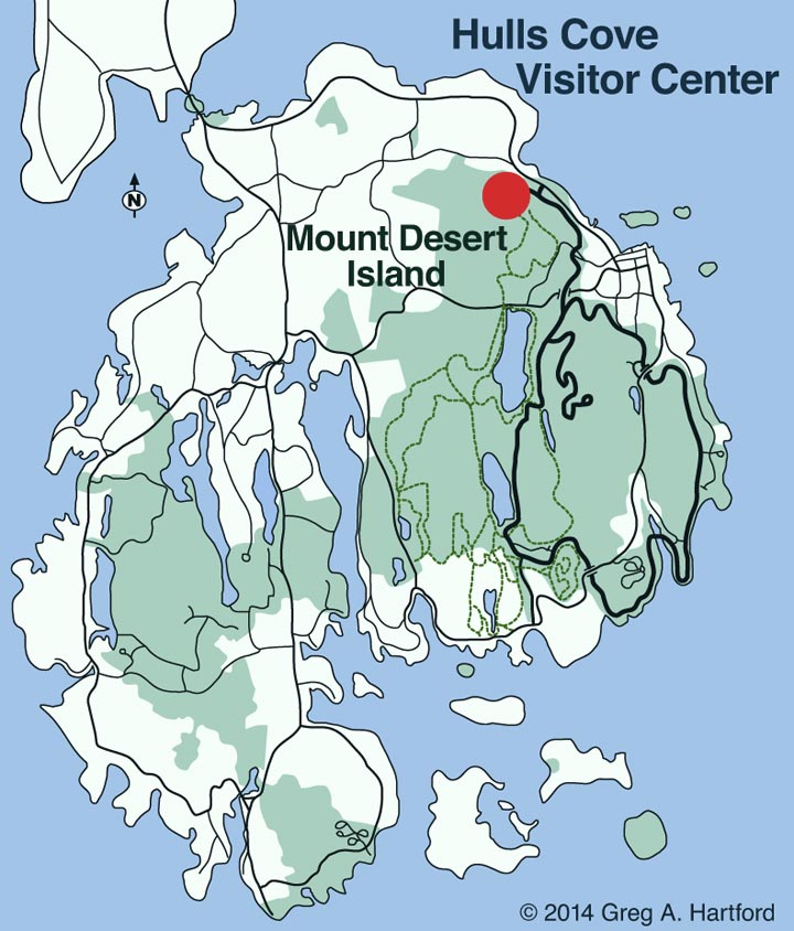
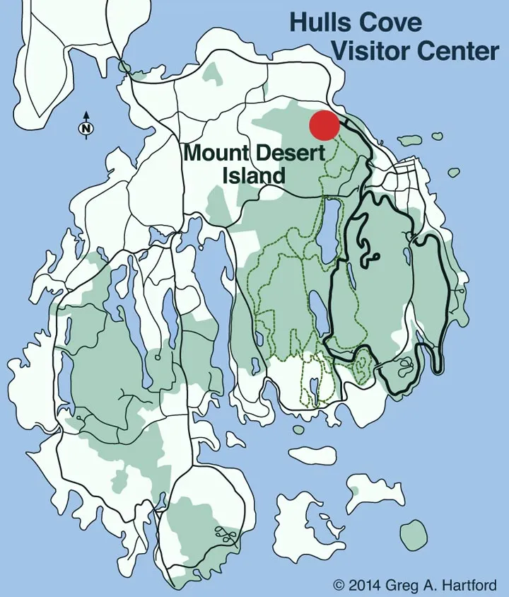
The Acadia National Park visitor center map system is more comprehensive than most visitors realize. During my first visit in 2014, I made the mistake of relying solely on my smartphone GPS – a decision that led to confusion and missed opportunities. The park's official map collection, primarily distributed through the Hulls Cove Visitor Center, represents decades of cartographic expertise tailored specifically for Mount Desert Island's unique geography.
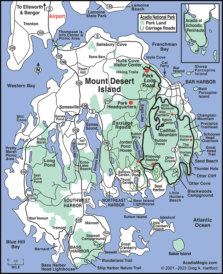
The main visitor center houses multiple map types, each serving distinct purposes. The primary Acadia National Park visitor center map covers the entire park system, including Mount Desert Island, Isle au Haut, and the Schoodic Peninsula. What surprised me most during my ranger conversation in 2019 was learning that this map undergoes annual updates to reflect trail conditions, road closures, and new facilities. The ranger, Sarah, explained that many visitors underestimate the importance of obtaining the current year's version.
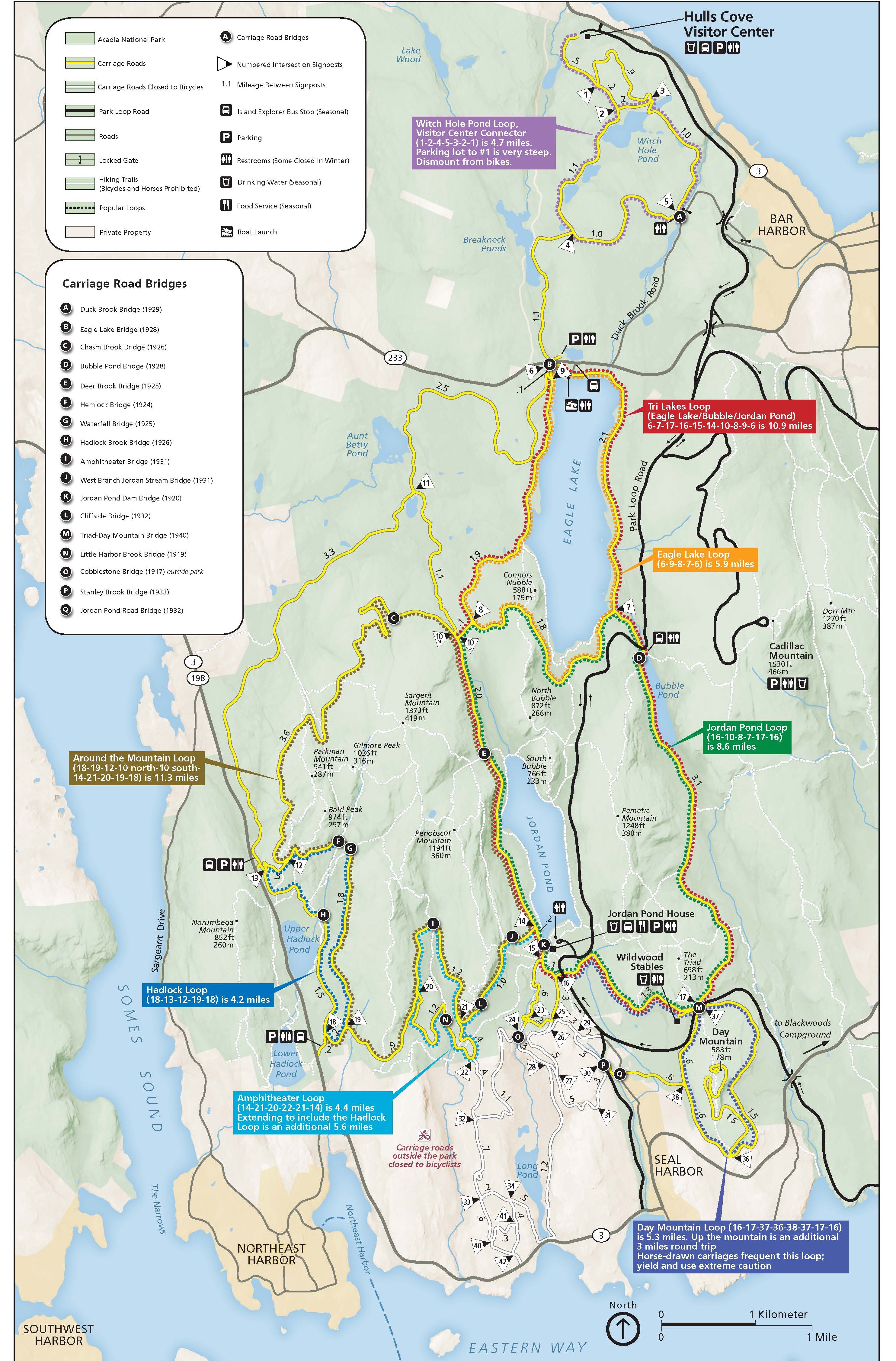
Beyond the general park map, specialized maps target specific activities. The carriage road map, featuring detailed elevation profiles, became my go-to resource for planning bicycle routes with my family. The Park Loop Road map highlights scenic viewpoints and provides timing estimates – crucial information when planning your optimal visit timing. These specialized resources complement the main Acadia National Park visitor center map, creating a comprehensive navigation system.
Pro Tip from My Experience:
Always collect multiple map types during your first visitor center stop. I learned this lesson after hiking halfway to Jordan Pond before realizing I needed the detailed trail map, not just the general park overview.
The digital integration aspect of the Acadia National Park visitor center map system has evolved significantly since my early visits. The NPS Acadia app now synchronizes with physical maps, allowing offline access to the same information displayed at the visitor center. However, cell service limitations throughout the park make physical backup maps essential – a lesson I learned the hard way during a foggy morning on Cadillac Mountain.
Understanding the visitor center operating hours is crucial for map collection. The Hulls Cove facility operates seasonally, typically from April through October, with reduced hours during shoulder seasons. During my October 2022 visit, arriving after 4:30 PM meant relying on the outdoor map displays – adequate but lacking the detailed information provided by ranger staff.
Recommended: Essential Acadia Guidebook

Acadia: The Complete Guide
Perfect companion to the official park maps with detailed trail descriptions and insider tips.
View on AmazonDigital vs Physical Maps: My Personal Experience
The evolution from purely physical to hybrid digital-physical mapping has transformed how I navigate Acadia National Park. My 2023 visit marked the first time I successfully integrated both approaches, creating a seamless navigation experience that I wish I'd discovered years earlier. The Acadia National Park visitor center map now exists in multiple formats, each offering unique advantages depending on your hiking style and technology comfort level.
Physical maps remain irreplaceable for trip planning and backup navigation. During my July 2022 backpacking trip to Isle au Haut, my smartphone died after photographing sunrise at Duck Harbor. The waterproof paper map from the visitor center became my lifeline for navigating back to the ferry dock. These physical versions of the Acadia National Park visitor center map resist weather conditions that would disable electronic devices, making them essential safety equipment.
My Digital Map Strategy
The NPS Acadia mobile app transformed my park navigation when I finally embraced it in 2021. This digital version of the Acadia National Park visitor center map offers GPS functionality, real-time trail conditions, and interactive features impossible with paper maps. However, I learned to download offline maps before entering areas with poor cell coverage – particularly around Jordan Pond and the Schoodic Peninsula.
Third-party apps like AllTrails complement the official digital resources. While hiking the Great Head Loop Trail, I discovered AllTrails provided elevation profiles and user-generated photos that enhanced the basic information from the standard Acadia National Park visitor center map. However, these apps shouldn't replace official park resources, which contain critical safety information and current conditions.
Lessons Learned:
Always carry both digital and physical versions of the Acadia National Park visitor center map. Digital for convenience and interactivity, physical for reliability and emergency backup. This redundancy has saved my hiking plans multiple times.
GPS accuracy varies significantly across different areas of Mount Desert Island. The dense forest canopy around Jordan Pond and Bubble Pond can interfere with satellite signals, making compass navigation skills valuable. The physical Acadia National Park visitor center map includes magnetic declination information – a detail often overlooked by digital-only navigators.
Battery management becomes crucial during extended park visits. My Samsung Galaxy typically lasts 6-8 hours with moderate map usage, GPS tracking, and photography. Portable batteries are essential, but they add weight to day packs. The physical map provides navigation security without battery dependence, explaining why experienced hikers always carry both formats of the Acadia National Park visitor center map.
Essential Acadia Planning Video
Essential Map Features and Navigation Tips
Understanding the symbols, legends, and specialized features of the Acadia National Park visitor center map dramatically improves navigation efficiency and safety. During my early visits, I overlooked crucial map elements that would have enhanced my experience and prevented several navigation mistakes. The ranger-led map orientation sessions at the Hulls Cove Visitor Center provide invaluable insights into maximizing these resources.
Critical Map Elements I Initially Missed
Trail difficulty ratings on the Acadia National Park visitor center map use a standardized system that differs from other national parks. The "strenuous" rating for Precipice Trail doesn't adequately convey the technical rock climbing required – something I discovered during my terrifying 2016 attempt with inadequate preparation. These ratings consider distance, elevation gain, and technical difficulty, but local conditions can significantly impact actual difficulty levels.
Tide information integration represents a unique feature of coastal park maps. The Acadia National Park visitor center map includes tide table references crucial for accessing certain areas safely. Bar Island becomes accessible only during low tide, and I've witnessed visitors stranded by rising water because they ignored tide timing information. The map's tidal pool locations also depend on these cycles for optimal wildlife viewing.
Safety Alert from Personal Experience:
Always check the weather symbols and seasonal closure indicators on your Acadia National Park visitor center map. I attempted Cadillac Mountain's North Ridge Trail during a winter closure and encountered dangerous ice conditions not apparent from casual observation.
Parking availability indicators have become increasingly important as park visitation grows. The map's parking symbols correlate with real-time availability apps, but arriving before 8 AM during peak season remains the most reliable strategy. Parking at the visitor center fills early, making alternative transportation planning essential.
Restroom and water source locations on the Acadia National Park visitor center map saved me during several long hiking days. The map distinguishes between potable and non-potable water sources – critical information for extended backcountry activities. Restroom facilities are limited along many trails, making pre-planning essential for family visits.
Emergency contact information and evacuation routes appear on current versions of the Acadia National Park visitor center map. Cell phone dead zones are clearly marked – information that proved valuable when I witnessed a hiking injury near Jordan Cliffs. The map's emergency procedures section includes specific protocols for different types of incidents, from minor injuries to severe weather events.
Trail Navigation Essential

Best Easy Day Hikes Acadia National Park
Perfect complement to the visitor center map with detailed trail descriptions and GPS coordinates.
View on AmazonSeasonal Considerations and Best Times to Visit
Seasonal variations dramatically affect the relevance and accuracy of your Acadia National Park visitor center map. My experiences across different seasons revealed that the same map can guide vastly different adventures depending on timing. Understanding these seasonal nuances has transformed my visit planning and helped me avoid numerous disappointments that plagued my earlier trips.
Spring Considerations (April-May)
Spring visits require special attention to trail conditions not always reflected on the standard Acadia National Park visitor center map. During my April 2021 visit, mud season had closed several trails marked as open on the general map. The seasonal addendum sheets available at the visitor center provide crucial updates, but checking the park's website before arrival prevents disappointment. Optimal visiting times depend heavily on winter weather patterns and spring thaw progression.
Waterfall viewing reaches its peak during spring snowmelt, making certain map features more relevant. The Acadia National Park visitor center map marks seasonal waterfalls that may appear insignificant on paper but become spectacular during April and May. I discovered several unmarked cascades near Great Head by following drainage patterns shown on topographic sections of the map.
Summer Peak Season (June-August)
Summer transforms the utility of parking and transportation information on the Acadia National Park visitor center map. The Island Explorer shuttle system operates at full capacity, making bus route overlays on the map essential for trip planning. My July experiences taught me that arriving at popular trailheads after 9 AM often means relying entirely on shuttle transportation.
Coastal fog patterns, common during summer months, aren't indicated on standard maps but dramatically affect mountain summit visibility. The Acadia National Park visitor center map's elevation contours help identify fog-prone areas, but local weather patterns require consultation with ranger staff. Summit views from Cadillac Mountain become unreliable during periods of maritime fog invasion.
Summer Strategy I've Developed:
Use the Acadia National Park visitor center map to identify less popular trails during peak season. My best summer experiences came from exploring marked but lesser-known paths like the Beehive Loop or Great Head Trail extensions.
Fall foliage season (September-October) adds interpretive value to the vegetation symbols on the Acadia National Park visitor center map. Deciduous forest areas, marked with specific symbols, provide the best color displays. The map's elevation information helps predict peak foliage timing, as higher elevations change earlier than coastal areas.
Winter access limitations significantly alter the practical utility of the standard Acadia National Park visitor center map. Many roads close seasonally, creating entirely different access patterns for winter activities. The specialized winter access map, available from November through March, becomes essential for cross-country skiing and snowshoeing activities.
Advanced Hiking Resource

Hiking Acadia National Park: Regional Hiking Series
Comprehensive trail guide with detailed maps and GPS coordinates for serious hikers.
View on AmazonAccessibility and Special Needs Information
The Acadia National Park visitor center map includes comprehensive accessibility information that often goes unnoticed by general visitors but proves invaluable for those with mobility limitations or families with special needs. My experience accompanying my elderly father in 2020 revealed how these accessibility features can make or break a park visit when properly understood and utilized.
Mobility-Accessible Features
Wheelchair-accessible trails receive special designation on the Acadia National Park visitor center map through distinct symbols and surface type indicators. The Great Meadow Loop and portions of the carriage road system accommodate wheelchairs, but surface conditions vary seasonally. My father's manual wheelchair handled the packed gravel surfaces well during dry conditions but struggled after rain events when surfaces became loose and muddy.
Accessible parking locations marked on the map often fill quickly during peak seasons. The visitor center accessibility information includes specific details about reserved spaces and proximity to accessible facilities. I learned to arrive before 9 AM to secure appropriate parking for mobility equipment transport.
Accessibility Insight:
The Acadia National Park visitor center map's accessibility symbols are standardized, but actual conditions may vary. Always confirm current accessibility status with ranger staff, especially after winter weather or maintenance activities.
Visual accessibility features on the map include Braille versions and high-contrast options available upon request. The visitor center maintains tactile maps and audio descriptions for popular trails. During my visit with a visually impaired friend, we discovered that the audio tour GPS coordinates align perfectly with the standard Acadia National Park visitor center map, creating a synchronized navigation experience.
Family-Friendly Accessibility
Stroller-friendly routes receive indication through surface type symbols on the Acadia National Park visitor center map. The Ocean Path and portions of the Great Head area accommodate wide-wheeled strollers, though rocky sections require all-terrain models. My experiences with young children taught me that the map's distance scales don't account for the slower pace required with strollers and frequent rest stops.
Service animal policies and designated relief areas appear on current versions of the map. These facilities proved essential during my 2022 visit with a veteran friend and his service dog. The information desk staff provides additional service animal resources not printed on the standard Acadia National Park visitor center map.
My Personal Experience: Learning from Mistakes
My relationship with the Acadia National Park visitor center map has evolved dramatically over seven visits. Initially dismissive of "tourist maps," I relied heavily on smartphone apps and online resources. This approach led to several memorable mistakes: getting lost in fog on Cadillac Mountain, missing the best tide pooling opportunities, and arriving at closed trailheads multiple times.
The turning point came during my 2019 visit when ranger Sarah spent twenty minutes explaining map features I'd overlooked. She showed me how tide charts correlate with coastal access points, how elevation contours predict weather patterns, and how seasonal closure indicators prevent wasted trips. That conversation transformed the Acadia National Park visitor center map from a basic navigation tool into a comprehensive planning resource.
Now I collect every available map version during my first visitor center stop, annotating them with personal notes and timing observations. This approach has eliminated navigation frustrations and opened opportunities I would have missed otherwise. The investment in understanding these maps pays dividends throughout each visit.
What Other Visitors Say
Amazon Reviewer - Trail Map Guide:
"The official park maps were good for general orientation, but I needed more detail for planning multi-day hiking. This guidebook filled the gaps perfectly, especially for elevation profiles and water source locations."
Reddit r/NationalPark User:
"Don't make my mistake of only downloading digital maps. Cell service is spotty throughout Acadia, and my phone died during a crucial navigation moment. Physical backup maps from the visitor center are essential."
Quora Travel Community:
"The accessibility information on the visitor center maps was incredibly helpful for planning with my elderly parents. The wheelchair-accessible trails and parking details made our visit possible and enjoyable."
Troubleshooting Common Map Issues
Even experienced visitors encounter challenges with the Acadia National Park visitor center map system. My seven visits have generated a comprehensive troubleshooting knowledge base derived from personal mistakes and observed visitor difficulties. Understanding these common issues and their solutions prevents frustration and enhances safety during park exploration.
Navigation Discrepancies
GPS coordinate mismatches between different map versions create the most frequent navigation problems. The Acadia National Park visitor center map uses NAD83 datum, while some smartphone apps default to WGS84, creating position errors of up to 300 feet. This discrepancy caused me to miss the Beehive Trail entrance during my 2018 visit, resulting in an unplanned detour through more difficult terrain.
Trail blazing inconsistencies between map indicators and actual field conditions occur seasonally due to weather damage and maintenance activities. The official Acadia National Park visitor center map shows established trail markers, but storm damage can remove blazes, creating navigation uncertainty. I've learned to identify natural navigation features like ridgelines and drainage patterns as backup orientation methods.
Troubleshooting Tip:
When trail markers don't match your Acadia National Park visitor center map, backtrack to the last confirmed location rather than continuing forward. I've prevented several potentially dangerous situations by following this rule consistently.
Weather-Related Challenges
Fog conditions render many map features temporarily useless for visual navigation. Coastal fog can reduce visibility to less than 50 feet, making landmark identification impossible. During my September 2021 Cadillac Mountain ascent, fog eliminated all visual references, forcing reliance on compass bearings and counting paces between known waypoints marked on the Acadia National Park visitor center map.
Seasonal flooding affects low-lying trail sections not adequately indicated on standard maps. The Great Meadow area experiences periodic inundation that blocks trails marked as passable on the Acadia National Park visitor center map. Local weather patterns and recent precipitation history provide better flooding predictions than map information alone.
Emergency communication challenges arise in cell service dead zones clearly marked on current map versions. The visitor center emergency procedures include specific protocols for different park areas, but understanding radio coverage limitations helps with emergency planning. Satellite communicators have become essential equipment for serious backcountry activities in areas where the Acadia National Park visitor center map indicates communication blackouts.
Complete Maine Guide

Frequently Asked Questions
Where can I get the most current Acadia National Park visitor center map?
The Hulls Cove Visitor Center provides the most current versions of all park maps, typically updated annually in April. Maps are also available at entrance stations, the Sieur de Monts Nature Center, and the visitor center gift shop. During winter months when Hulls Cove is closed, maps are available at the Bar Harbor Chamber of Commerce and online through the NPS website. I always recommend collecting multiple map types during your first visitor center stop to ensure you have comprehensive coverage for your planned activities.
Are digital versions of the Acadia National Park visitor center map available offline?
Yes, the official NPS Acadia app includes downloadable offline maps that mirror the visitor center versions. I strongly recommend downloading these before arriving, as cell service is limited throughout much of the park. The app includes GPS functionality that works without cell service, though GPS accuracy varies in dense forest areas. AllTrails and other third-party apps also offer offline capabilities, but they should supplement rather than replace official park resources. Physical backup maps remain essential for safety, especially during extended backcountry activities where battery life becomes a concern.
How accurate are the trail difficulty ratings on the visitor center map?
Trail difficulty ratings on the Acadia National Park visitor center map use a standardized system considering distance, elevation gain, and technical requirements. However, these ratings don't account for individual fitness levels, weather conditions, or seasonal variations. The "strenuous" rating for trails like Precipice or Beehive indicates technical rock scrambling that requires upper body strength and comfort with heights. I've found that ratings serve as general guidelines, but consulting with ranger staff about current conditions and your specific abilities provides more reliable difficulty assessment for trip planning.
Does the visitor center map include information about accessibility for people with disabilities?
Current versions of the Acadia National Park visitor center map include comprehensive accessibility symbols indicating wheelchair-accessible trails, parking areas, restrooms, and facilities. The Great Meadow Loop and portions of the carriage road system accommodate wheelchairs and mobility devices. Detailed accessibility information is available at the visitor center, including Braille maps and audio tour options. Surface conditions vary seasonally, so confirming current accessibility status with ranger staff ensures accurate planning. The visitor center also maintains information about visual and hearing accessibility resources throughout the park.
What should I do if my GPS coordinates don't match the visitor center map?
GPS coordinate discrepancies typically result from different datum systems – the visitor center map uses NAD83 while many apps default to WGS84, creating position errors up to 300 feet. When coordinates don't align, prioritize established trail markers and physical landmarks over GPS readings. The park's official app coordinates align with visitor center maps and provide the most reliable digital navigation. If you encounter significant discrepancies, backtrack to your last confirmed position rather than continuing forward. Poor GPS accuracy in dense forest areas and near cliff faces makes compass navigation skills valuable backup techniques for serious hikers.
Are there seasonal differences in map accuracy and usefulness?
Seasonal variations significantly affect map accuracy and utility. Winter closures, mud season limitations, and storm damage can make portions of the map temporarily inaccurate. The visitor center provides seasonal addendum sheets with current conditions, but these updates may not reflect rapid changes. Optimal visiting times depend on your planned activities and seasonal preferences. Spring visits require special attention to trail closures during mud season, while winter maps differ significantly from summer versions due to road closures and limited facility operations. Always check current conditions with ranger staff regardless of map currency.
Pros and Cons: Physical vs Digital Maps
Physical Map Advantages:
- No battery dependence
- Weather-resistant materials
- Large-scale overview capability
- No signal requirements
- Easy group sharing and annotation
Physical Map Limitations:
- Static information, no real-time updates
- Can be damaged by weather
- Limited detail in pocket-sized versions
- No GPS positioning capability
- Requires compass skills for precise navigation
Additional Resources and References
- Official NPS Acadia Maps Collection - Government source for all official park maps
- Friends of Acadia - Non-profit supporting park maintenance and accessibility improvements
- Island Explorer Transportation - Official shuttle system information and route maps
- National Weather Service - Caribou - Local weather forecasts affecting trail conditions
Conclusion
The Acadia National Park visitor center map represents far more than a simple navigation tool – it's your gateway to safely experiencing one of America's most beautiful and complex national parks. Through seven visits and countless mapping mistakes, I've learned that understanding these resources thoroughly transforms good park visits into extraordinary adventures.
My journey from map-dismissive smartphone navigator to comprehensive map advocate illustrates how proper preparation enhances every aspect of the Acadia experience. The visitor center's map collection, when properly understood and utilized, prevents common navigation mistakes while revealing opportunities that casual visitors miss. Whether you're planning your first visit or returning for deeper exploration, investing time in map familiarity pays dividends throughout your stay.
The integration of digital and physical mapping resources has revolutionized park navigation, but successful implementation requires understanding each format's strengths and limitations. My hybrid approach – collecting comprehensive physical maps while utilizing digital tools for real-time information – has eliminated navigation frustrations while maintaining safety margins essential for wilderness activities.
Seasonal considerations, accessibility requirements, and emergency preparedness all depend on thorough map knowledge that extends beyond basic trail identification. The visitor center staff provides invaluable context that transforms static map information into dynamic trip planning resources tailored to your specific needs and abilities.
As Acadia National Park continues evolving to accommodate increasing visitation while preserving its natural character, the importance of proper planning through comprehensive map utilization becomes even more critical. The Acadia National Park visitor center map system will undoubtedly continue expanding and improving, but the fundamental principles of careful preparation, redundant navigation resources, and respect for natural conditions remain constant. Your investment in understanding these tools ensures safer, more rewarding adventures in this remarkable coastal wilderness for years to come.