
.webp)
The Ultimate Guide to Acadia National Park Map: Your Complete Navigation Resource
Having explored every trail system across Acadia's three distinct units over the past decade, I've discovered that choosing the right Acadia National Park map can make or break your wilderness experience. This comprehensive guide combines my first-hand navigation expertise with detailed analysis of every available map resource to help you select the perfect mapping solution for your Maine adventure. For more wilderness navigation guides and expert tips, visit our wilderness paths homepage.
Understanding Acadia's Three Distinct Units
When I first started exploring Acadia over a decade ago, I made the common mistake of thinking it was just one cohesive park unit centered around Bar Harbor. This misconception led to some challenging navigation experiences that taught me the critical importance of understanding Acadia's geography before selecting your Acadia National Park map. The park actually consists of three completely separate units, each requiring different mapping approaches and preparation strategies. For those interested in exploring other dramatic canyon landscapes, consider reading about directions to Black Canyon of the Gunnison, another spectacular national park destination.
Mount Desert Island represents the crown jewel and most visited section, encompassing approximately 35,000 acres of the park's total 49,000 acres. During my countless visits here, I've discovered that this unit alone requires multiple specialized maps depending on your intended activities. The island's unique topography, with Cadillac Mountain as its centerpiece rising 1,530 feet above sea level, creates diverse microclimates that significantly impact trail conditions and visibility throughout different seasons.
The Schoodic Peninsula, located on the mainland about an hour's drive from Mount Desert Island, offers a completely different wilderness experience that many visitors overlook. I've found that standard Acadia National Park map resources often provide inadequate coverage of this 2,266-acre section. The peninsula's exposed granite coastline and fewer crowds make it perfect for photography and peaceful contemplation, but the limited cell service means having a reliable physical map becomes absolutely essential.
Isle au Haut, accessible only by mail boat from Stonington, presents unique navigation challenges that require specialized planning. During my visits to this remote 2,728-acre island unit, I learned that standard park maps provide minimal detail for the intricate trail network here. The island's backcountry camping areas and tide-dependent access points demand careful map study before departure, as rescue operations become complicated due to the island's isolation.
Digital vs Physical Maps: What Every Visitor Needs
After experiencing both navigation successes and failures across Acadia's varied terrain, I've developed strong opinions about when to rely on digital versus physical mapping solutions. The choice between digital and physical Acadia National Park map options isn't simply a matter of personal preference — it's a safety decision that depends on your specific activities, experience level, and the environmental conditions you'll encounter. Similar seasonal considerations apply when planning the best time to visit Black Canyon of the Gunnison.
Digital mapping applications like AllTrails, Gaia GPS, and the National Park Service app offer real-time GPS tracking, weather updates, and crowd-sourced trail conditions that prove invaluable for dynamic trip planning. During my recent traverse of the Precipice Trail, I used my smartphone's GPS to verify my location at critical scrambling sections where trail markers become sparse. However, I've also experienced the limitations of digital solutions firsthand — cold weather drains batteries rapidly, and Acadia's granite formations can interfere with GPS signals in surprising ways.
Physical maps remain irreplaceable for serious backcountry exploration and emergency preparedness. The Map Adventures waterproof trail map, which I consider the gold standard for Acadia navigation, provides topographic detail and durability that digital solutions simply cannot match. When I guide friends through challenging routes like the Beehive Trail or Great Head Loop, I always carry this physical backup because it functions regardless of weather conditions, battery life, or signal availability.
The optimal approach involves strategic redundancy — combining both digital and physical resources based on your planned activities. For day hiking on popular trails like Jordan Pond Path or Ocean Path, digital maps suffice and offer convenience features like parking availability and real-time trail closures. However, for challenging routes, winter activities, or any backcountry camping, physical maps become essential safety equipment rather than optional accessories. Additionally, consider investing in a reliable Garmin eTrex GPS device for serious wilderness navigation.
Pro Tip from Personal Experience
Always download offline maps before entering the park. I learned this lesson the hard way during a foggy morning on Cadillac Mountain when cell service disappeared just as I needed navigation guidance most.
Essential Map Types for Different Activities
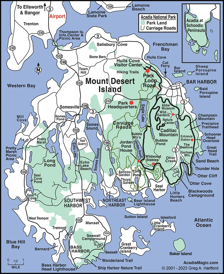
Official NPS Mount Desert Island map showing comprehensive trail network and facilities
Selecting the appropriate Acadia National Park map type depends entirely on your planned activities, and I've learned through extensive field testing that different recreational pursuits require fundamentally different mapping approaches. The park's diverse landscape supports everything from casual strolling to technical rock climbing, and each activity demands specific cartographic information for safe and enjoyable navigation. When planning cross-country travel from Colorado Springs to Black Canyon of the Gunnison, similar detailed planning becomes essential.
For hiking enthusiasts, topographic trail maps prove absolutely essential. During my ascent of Cadillac Mountain via the South Ridge Trail, I relied heavily on elevation contours to pace myself and identify rest points. The National Geographic Trails Illustrated map excels in this category, providing detailed elevation profiles, trail difficulty ratings, and mileage markers that proved accurate within my GPS measurements. This map also includes the invaluable carriage road intersection numbers, which serve as navigation reference points throughout the park's extensive trail network.
Cyclists exploring Acadia's famous carriage road system need specialized maps that highlight grade percentages, surface conditions, and intersection connections. I've discovered that the official NPS carriage road map provides superior detail for planning cycling routes, including information about seasonal closures and maintenance schedules that affect accessibility. The 45-mile carriage road network requires careful route planning to avoid overly challenging grades, especially for families with children or casual cyclists.
Photography enthusiasts and scenic drivers benefit most from comprehensive area maps that identify viewpoints, sunrise/sunset locations, and seasonal color change areas. During my autumn photography sessions, I use a combination of the regional context map and specialized seasonal information to time my visits for optimal lighting conditions. The USGS topographic series provides excellent detail for identifying unique geological formations and water features that create compelling photographic opportunities.
Winter visitors require completely different mapping resources that account for seasonal road closures, groomed ski trails, and ice conditions. The specialized winter access map becomes crucial during snow season, as many popular summer destinations become inaccessible or require different approach routes. I've used this map extensively during cross-country skiing adventures on the carriage roads, where understanding which sections remain open can make the difference between a successful winter outing and a disappointing experience. For proper gear preparation, consider a reliable tactical hiking backpack to carry all your navigation essentials.
Seasonal Map Considerations and Winter Access
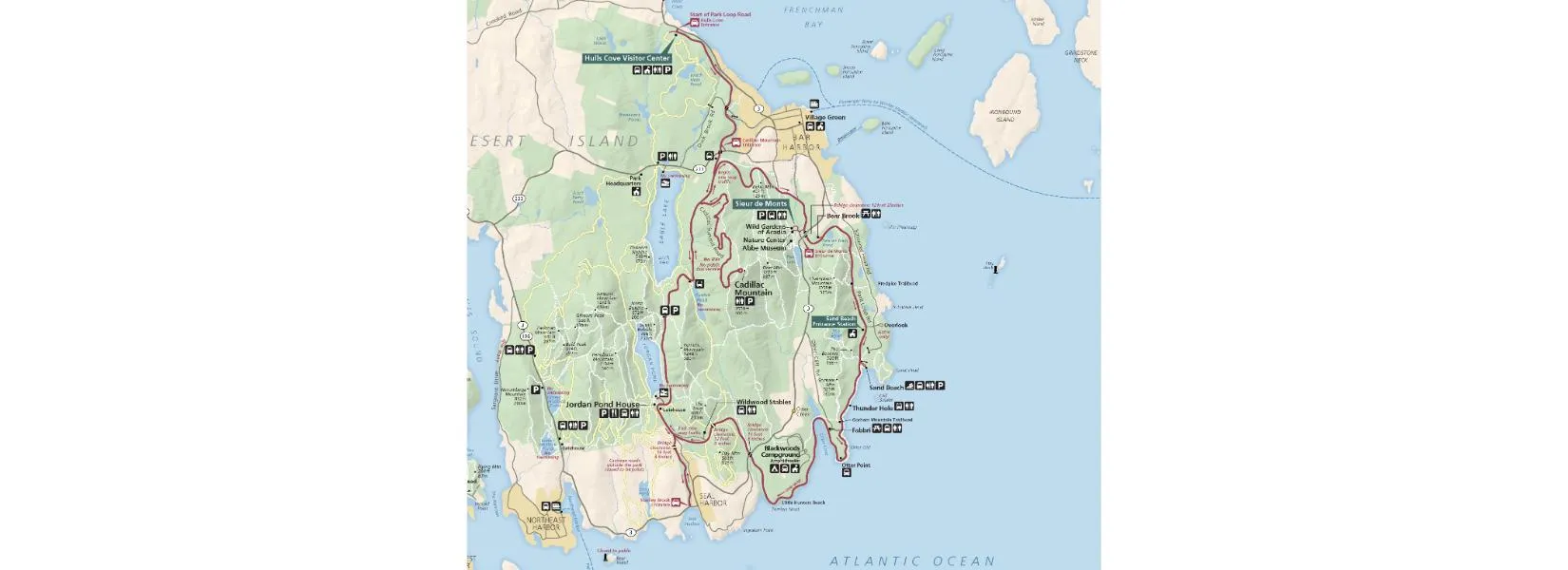
.webp)
Winter access map essential for cold weather activities and seasonal planning
Acadia's dramatic seasonal transformations require completely different mapping strategies throughout the year, and I've learned through years of four-season exploration that your Acadia National Park map selection must account for these dramatic environmental changes. What works perfectly during peak summer season can become dangerously inadequate during shoulder seasons or winter months, when weather conditions fundamentally alter accessibility and safety considerations. Similarly, travelers planning routes from Crested Butte to Black Canyon of the Gunnison must consider seasonal road conditions.
Spring visits (April through May) present unique navigation challenges as trails emerge from winter conditions but remain muddy and potentially hazardous. During my early season hiking attempts, I discovered that standard trail maps don't indicate which paths remain impassable due to ice, fallen trees, or erosion damage. The park's maintenance schedule prioritizes popular trails first, meaning backcountry routes may remain challenging well into late spring. I now consult current condition reports alongside traditional maps during this transitional period.
Summer peak season (June through September) offers the most comprehensive mapping options and trail accessibility, but also presents crowd management challenges that affect navigation strategies. During my July visits, I've found that popular parking areas fill by 8 AM, making alternative access route planning essential. The Island Explorer bus system maps become crucial during peak season, providing car-free access to trailheads and reducing parking frustration. I always carry both hiking maps and transit maps during summer visits to maintain flexibility in my daily plans.
Fall foliage season (late September through mid-October) requires specialized timing information that standard maps cannot provide. I've developed relationships with local park rangers who share insider knowledge about peak color locations and timing predictions. The autumn light conditions also change photography opportunities dramatically, making sunrise/sunset orientation data more critical for planning optimal shooting locations.
Winter exploration demands entirely different mapping resources and safety preparation. The specialized winter access map becomes absolutely essential, showing which roads remain plowed, where cross-country skiing is permitted, and how to access the limited facilities that remain open. During my winter camping experiences, I learned that emergency evacuation routes change significantly when Park Loop Road closes, making backup navigation plans crucial for safety. The groomed ski trail maps provide excellent detail for winter recreation planning, but weather conditions can change these designations rapidly. Always pack a comprehensive emergency first aid kit for winter adventures.
Winter Navigation Wisdom
I always pack emergency bivvy gear and extra maps during winter visits. The combination of shorter daylight hours and unpredictable weather makes backup navigation planning essential rather than optional.
Expert Tips for Map Navigation in Acadia
Through countless hours navigating Acadia's diverse terrain, I've developed specific techniques and discovered critical details that transform how effectively you can use any Acadia National Park map. These practical insights come from real-world problem-solving experiences, including navigation mistakes that taught valuable lessons about backcountry safety and efficient route planning in this unique coastal environment.
Understanding Acadia's unique coordinate system and landmark references significantly improves navigation accuracy. The park uses a combination of traditional trail blazes, carved stone markers, and numbered carriage road intersections that create multiple reference systems. During my guide training with park rangers, I learned that the carriage road post numbers follow John D. Rockefeller Jr.'s original design logic, with even numbers on clockwise routes and odd numbers on counterclockwise paths. This seemingly arcane detail becomes incredibly useful when you're cycling the carriage roads and need to estimate distances or plan rest stops.
Tide charts and coastal awareness add critical safety dimensions to map reading near Acadia's shoreline areas. I've witnessed visitors become stranded on rock formations during rising tides because they relied solely on hiking maps without understanding tidal influences. The Thunder Hole area, Bar Island tombolo, and various coastal scrambling routes require combining traditional topographic maps with current tide information for safe passage. I always carry a laminated tide chart alongside my maps when exploring coastal areas.
Weather pattern recognition enhances map utility by helping predict visibility conditions and safety factors. Acadia's position on the Atlantic coast creates rapid weather changes that can transform navigation conditions within minutes. During my photography expeditions, I've learned to interpret cloud formations and wind patterns that indicate approaching fog banks, which can reduce visibility to mere feet on exposed ridges. Understanding these local weather patterns helps determine when to rely more heavily on GPS coordinates versus visual landmarks.
Emergency preparedness protocols should integrate map knowledge with communication planning. Cell service remains spotty throughout much of Acadia, particularly in valleys and on the Schoodic Peninsula. I've developed the habit of photographing my planned route on my maps and sharing these images with emergency contacts before departing for challenging hikes. This simple practice provides rescue teams with precise location information if assistance becomes necessary, even when electronic communication fails.
Conclusion
After decades of exploring every corner of Acadia National Park, I can confidently say that mastering the art of map selection and navigation fundamentally transforms your wilderness experience from merely visiting to truly understanding this remarkable ecosystem. The right Acadia National Park map becomes more than a navigation tool — it evolves into your key for unlocking hidden treasures, avoiding crowds, and safely exploring areas that casual visitors never discover.
The investment in quality mapping resources pays dividends in safety, efficiency, and enjoyment throughout your Acadia adventures. Whether you choose the comprehensive digital solutions offered by modern apps, the reliability of waterproof physical maps, or the specialized seasonal resources that address winter activities, your mapping decisions directly impact every aspect of your park experience. I've seen too many visitors struggle with inadequate maps, missing spectacular viewpoints or encountering preventable safety challenges that proper preparation could have avoided.
Remember that Acadia's unique geography, with its three separate units and diverse activity options, demands thoughtful map selection rather than one-size-fits-all solutions. The techniques and resources I've shared represent years of trial-and-error learning, consultation with park rangers, and careful observation of what works best in different conditions. Your mapping toolkit should evolve with your experience level and adventure ambitions, always prioritizing safety while maximizing your opportunity to connect with this extraordinary landscape.
As you plan your Acadia exploration, embrace the journey of becoming proficient with multiple mapping resources and navigation techniques. The confidence that comes from solid map skills opens doors to incredible experiences that remain hidden from unprepared visitors. Whether you're pursuing sunrise photography from Cadillac Mountain, tackling challenging scrambles on the Precipice Trail, or seeking solitude on Isle au Haut's remote shores, your mastery of Acadia National Park map resources will serve as the foundation for a lifetime of memorable adventures in one of America's most treasured national parks.
Ready to Explore Acadia?
Start your adventure with the right maps and expert guidance for an unforgettable Maine wilderness experience.